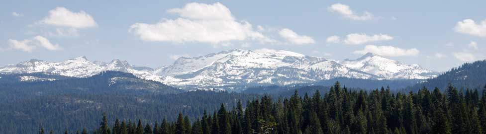
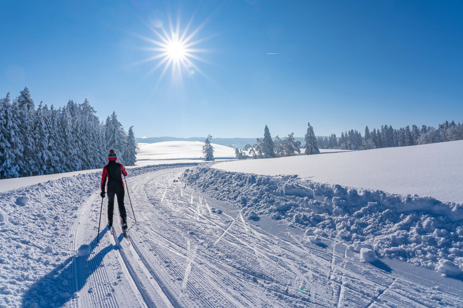
Cross Country Skiing around Echo Summit
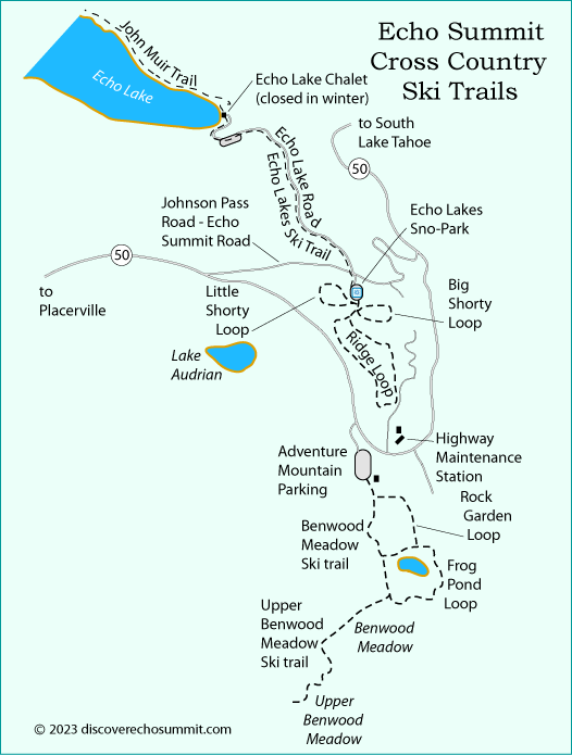
Cross Country Skiing around Echo Summit features a number of excellent beginning, intermediate, and advanced cross country and snowshoe trails. The Echo Lakes Sno-Park at Echo Summit serves as the starting point for most of the trails along the top of the pass. The Sno-Park is on the north side of Highway 50, off Johnson Pass - Echo Summit Road. Ski trails are marked with blue diamonds.
Farther west along Highway 50 at Strawberry are several more marked ski trails. The 42-Mile Day Use area serves as the staging area for these routes.
Loon Lake Cross Country Skiing
A large network of Nordic trails begin at Loon Lake in the Crystal Basin. To see maps and read descriptions of those routes see Cross Country Skiing at Loon Lake.
Echo Lake Sno-Park
Echo Lake Sno-Park at Echo Summit serves as a great base for cross country skiing in that area. The Sno-Park is on the north side of Highway 50. The parking lot on the south side of Highway 50 is now part of Adventure Mountain, a snow play area. For information on Adventure Mountain see Echo Summit Snow Play.
Sno-Parks are parking areas maintained in the winter to allow people to park safely and pursue winter activities such as cross-county skiing or snow shoeing. They have pit toilets available. To use a Sno-Park you must have a permit. You can purchase a day permit for $15 or an annual pass (Nov. 1 - May 30) for $40. They are good at any California, Oregon, Washington, or Idaho Sno-Park.
Near Echo Summit you can be purchase Sno-Park permits at the following places:
- Kyburz Silver Fork Store 13200 Highway 50, Kyburz
- Strawberry Station, 17481 Highway 50, Twin Bridges
- Tahoe Roadrunner, 2933 Highway 50, South Lake Tahoe
- Tahoe Ski Company, 3131 Harrison Ave., South Lake Tahoe
- Tahoe Paradise Chevron, 2986 Highway 50., South Lake Tahoe
For a complete list of locations that sell Sno-Park permits in California, see
California Sno-Park Vendors
Permits may also be purchased online for an additional $1.95 at
Sno-Park Permits.
Echo Summit Nordic Ski Trails
Nordic Trails on the South Side of Highway 50
Benwood Meadow Trail
Distance: 0.6 miles one way
Elevation changes: +100 feet (7,400' - 7,500')
The Benwood Meadow Trail begins at the southeast corner of what is now the Adventure Mountain parking lot (formerly Echo Summit Sno-Park). The route leads up one of the ski runs of the now closed Echo Summit Ski Resort. After a short climb you reach a fairly level section that provides access to two loop trails, to Benwood Meadow, and to the start of the Upper Benwood Meadow Trail.
Rock Garden Loop
Distance: 0.9-mile loop
Elevation changes: Level (7,500')
The Rock Garden Trail leaves the Benwood Meadow Trail after about 400 feet, angling to the left. The Rock Garden Trail takes you out to a rocky shelf above the Upper Truckee River and then loops back to rejoin the Benwood Meadow Trail about a quarter mile south of the point where you originally left it.
Frog Pond Loop
Distance: 1-mile loop
Elevation changes: Level (7,500')
Frog Pond Loop is adjacent to Rock Garden Loop. The two trails share a portion of their loops and can easily be combined. Begin the Frog Pond Loop about 0.4 miles south on the Benwood Meadow Trail. The loop circles Frog Pond and then returns to Benwood Meadow Trail, skirting Benwood Meadow.
Upper Benwood Meadow
Distance: 1.4 miles one way
Elevation changes: +300 feet (7,500' - 7,800')
Access by heading south from the Adventure Mountain parking lot via the Benwood Meadow Trail. Just before Benwood Meadow the Upper trail leads off to the right, climbing a steep incline into a rocky basin containing Upper Benwood Meadow. Because of its steepness and narrow trail, it is rated as difficult.
Echo to Kirkwood (Caples Lake, Highway 88)
Distance: 11 miles one way
Elevation changes: +1,900 feet, - 1,000' (7,300' - 9,200' - 8,200')
This long ski tour is for experienced back country skiers. It involves steep climbs and descents along with gently rolling terrain. Spectacular views of Lake Tahoe, the Crystal Range, Round Top, and Caples Lake await those who take the trail.
As you approach Highway 88, following the blue diamond trail markers, you will likely find yourself on groomed trails which are part of the Kirkwood Cross Country Ski Trail system. As long as you stay with the blue diamond markers you do not need to purchase a trail pass. About 2½ miles of the route are shared with snowmobiles.
Skiers should go prepared to spend the night along the trail in case circumstances do not allow you to complete the trail in one day. Those planning to use the trail should study the information on the Eldorado National Forest website. It includes a map of the trail: Echo to Kirkwood Cross Country Ski Trail
Nordic Trails on the North Side of Highway 50
Little Shorty Loop
Distance: 0.4-mile loop
Elevation changes: Level (7,300')
Go 100 feet south of Sno-Park on stem trail. Watch for blue diamonds and blue signs with yellow arrows to guide you. The Little Shorty Trail meanders through forest over gently rolling terrain.
Big Shorty Loop
Distance: 0.5-mile loop
Elevation changes: Level (7,300')
Start 200 feet south of the Little Shorty Loop and follow the trail around a small basin. The trail returns to the main stem trail south of its starting point.
Ridge Loop
Distance: 1.1-mile loop
Elevation changes: +100 feet (7,300' - 7,400')
This is a slightly more difficult trail than the two listed above. It involves some steeper terrain. Access it from the southern end of the stem trail that leads south out of the Sno-Park.
Echo Lakes Ski Trail
Distance: 1.1 miles
Elevation changes: Level (7,300')
The trail follows the Echo Lakes Road toward Echo Lakes. Views of the lakes reward those who take this trail.
Desolation Wilderness
Many cross country skiers and snowshoers use the Echo Lakes Sno-Park as a starting point to head into the Desolation Wilderness. Permits are required. Often ice on the lakes is unsafe. Although it is slower going, prudent skiers and snowshoers stick to the shorelines.
Avalanche Danger
Avalanche danger is always a concern in winter back country travel. It is wise to travel with experienced leaders who recognize the dangers and can guide your group. There are courses available to teach you about avalanche and backcountry winter travel safety:
Mountain Education
Donner Summit Avalanche Seminars
North American Ski Training Center
Alpine Skills International
Mountain Adventure Seminars
Back Country Safety
- Check with the Forest Service before heading out to be sure conditions are safe on the route you will be using.
- Always carry emergency supplies and a cell phone.
- Let a responsible person know where you are going and when you will be returning.
- Travel with at least one other person.
- Carry an emergency locator beacon when skiing off trail.
The Sierra Avalanche Center provides information about avalanche conditions in the Sierra from Yuba Pass in the north to Ebbetts Pass in the south. Visit their website at Sierra Avalanche Center.
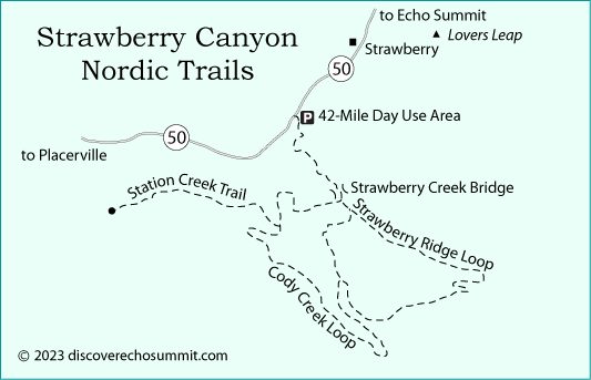
Strawberry Canyon Nordic Trails
Strawberry Ridge Loop
Distance: 5-mile loop
Elevation changes: +1,200 feet (5,600' - 6,800')
Begin at the 42-Mile Day Use Area on Highway 50 near Strawberry. Head west from the trailhead, crossing Strawberry Creek bridge, and then turn south. The trail makes a challenging climb up and over a ridge before circling back to the bridge.
Cody Creek Loop
Distance: 4.5-mile loop
Elevation changes: +800 feet (5,800' - 6,600')
Begin at the Strawberry Creek Bridge and head southwest, climbing 2½ miles. The trail crosses Cody Creek and then loops back down to the Strawberry Creek bridge. Parts of the trail are difficult.
Station Creek Trail
Distance: 2.5-mile one way from trailhead
Elevation changes: +800 feet (5,900' - 7,500')
This trail leads off the Cody Creek Loop trail and climbs for 1½ miles to a view point. The grade is gentle, making it a good route for beginners. From the trail skiers gain views of Lovers Leap, Ralston Peak, and the South Fork of the American River Canyon.
TOP
Camp Richardson Mountain Sports Center
Highway 89
South Lake Tahoe, CA
(530) 542-6584
Mountain Sports Center
Cross country ski and snowshoe rentals
Powder House Ski and Snowboard
4045 Lake Tahoe Blvd.
South Lake Tahoe, CA
(530) 542-6222
Powder House Ski and Snowboard
Cross country ski package (includes boots) $34
snowshoe package (includes boots) $34
Sunrise Ski-Snowboard Rental
at Meyers Trading Post
3200 Hwy. 50
Tahoe Paradise, CA
(530) 577-3176
Sunrise Ski-Snowboard Rental
Cross country ski package
Skis only, boots, poles
Snowshoes
Snow clothing rentals
Other Passes - Other Nordic Trails
Donner Summit

At the north end of Lake Tahoe around Donner Summit (Interstate 80) cross country ski routes lead out over the high terrain. Royal Gorge's and Tahoe Donner's groomed cross country ski trails are among the most expansive in the country. Learn about all the best country trails at Around Donner Summit.
Carson Pass
One of the classic ski trails leads from Echo Summit to Kirkwood on the Carson Pass. There are plenty of other exciting cross country ski trails on Carson Pass. Kirkwood runs a cross country center with groomed trails. Or for the more adventurous, head out from Carson Pass into the Mokelumne Wilderness. For information, see Up and Over Carson Pass.
Ebbetts Pass
A little farther south Ebbetts Pass has miles of cross country trails to explore. Bear Valley has a cross country center with groomed trails. Many skiers and snowshoers enjoy heading up Highway 4 past Lake Alpine or out to Spicer Meadow Reservoir. To learn more, visit Ebbetts Pass Adventures.
Sonora Pass
Sonora Pass (Highway 108) has numerous cross country routes. Some lead around the Dodge Ridge area while others strike out from the Sno-Park near Strawberry. Find all the information on Sonora Pass Vacations.