Mileages From Sacramento
- Placerville - 44 miles
- Crystal Basin - 82 miles
- Wrights Lake - 87 miles
- Twin Bridges - 85 miles
- Echo Summit - 92 miles
- S. Lake Tahoe - 103 miles
High Sierra Trails
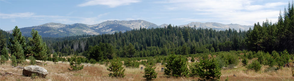
Backpacking around Echo Summit
The Desolation Wilderness is by far the most popular destination for backpackers in the Echo Summit area, which is why the wilderness has among the strictest permit regulations in California. You'll find complete information about wilderness permits and planning a trip into the Desolation Wilderness on the Desolation Wilderness Permit Information page.
Don't overlook other areas of the Eldorado National Forest for great backpacking. Among them are the Pacific Crest Trail heading south to Carson Pass and the fabulous Meiss Country.
Echo Lakes
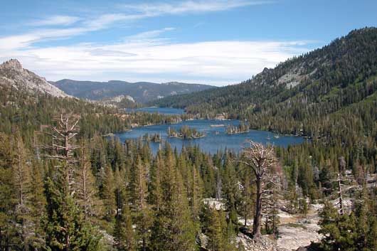
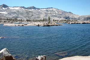
Desolation Wilderness Destinations
Lake Aloha
Trailhead: Echo Lakes
Distance: 6 miles one way
Elevation changes: +950 feet (7,400' - 8,350')
The open countryside around Lake Aloha offers secluded campsites tucked away in forest or among
the rocks, breathtaking views of surrounding peaks, and miles of terrain to explore. Set out from the Echo Lakes
trailhead along the Pacific Crest Trail going north along the shores of the Echo Lakes. You can bypass this 2.5
mile section of the hike by taking the Echo Chalet Water Taxi.
From Echo Lakes the trail passes Tamarack Lake and Lake of the Woods as it climbs a ridge before a gradual descent
to Lake Aloha.
Susie Lake
Trailhead: Fallen Leaf Lake
Distance: 4 miles one way
Elevation changes: +1,300 feet (6,500' - 7,800')
Climb along beautiful Glen Alpine Creek as it cascades down from the high country. Enjoy waterfalls and views of Mount Tallac. Susie Lake is well located to serve as a base camp for day hikes to Lake Aloha, Gilmore Lake, and the summit of Mount Tallac.
Lake of the Woods
Trailhead: Twin Bridges
Distance: 4.5 miles one way
Elevation changes: +2,400 feet (6,400' - 8,800')
The classic hike from near Twin Bridges on Highway 50 up the ridge past Horsetail Falls is popular with many backpackers. Along the way a short detour takes you to the top of 9,235-foot Ralston Peak. From its summit you can look out across the Desolation Wilderness and down to Echo Lakes. From the ridge near Ralston Peak the trail makes a gradual descent to Lake of the Woods. Camp at the designated campsites marked by the 4x4 posts.
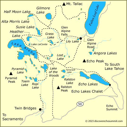
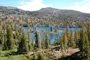
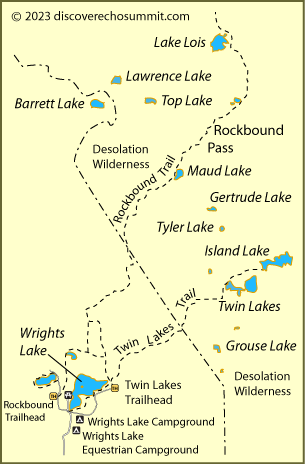
Island Lake
Trailhead: Wrights Lake
Distance: 3 miles one way
Elevation changes: +2,200 feet (6,950' - 8,150')
From Wrights Lake make the climb out of the forest to a cirque at the foot of the Crystal Range. Choose between Twin Lakes and Island Lake for your camp.
Photographers spend hours here catching reflections on the lakes and spectacular sunrises and sunsets. Anglers do well fishing for rainbow trout in Twin Lakes and golden trout in Island Lake.
Lake Lois
Trailhead: Wrights Lake
Distance: 6.5 miles one way
Elevation changes: +1,600 feet -300 feet (7,000' - 8,600' - 8,300')
The hike over Rockbound Pass is one of the best ways to enter the Desolation Valley, launching you right into the heart of the back country. Follow the Rockbound Trail from Wrights Lake north over gentle terrain for the first three miles. Then begin a steady climb past Maud Lake and eventually to the top of Rockbound Pass. After that it is an easy descent past Lake Doris and over to Lake Lois. From there you can make the short hop over to Lake Schmidell and a host of other lakes.
Backpacking Outside Desolation Wilderness
Pacific Crest Trail - Southbound to Carson Pass
Trailhead: Echo Summit
Distance: 12 miles one way
Elevation changes: +3,280 feet -1,900 feet (7,200' - 9,000' - 8,600')
The hike between Carson Pass and Echo Summit is easier going north, so if you are
planning an out-and-back trip, Echo summit is the place to begin, putting your hardest work on the first half of your trip. The trail cruises along easily for the first 2 miles to Benwood Meadow and then begins a steep climb, gaining 1,200 feet in one mile. From there on, the trail drops and climbs no more than several hundred feet at a time.
At mile 7.5 you pass Showers Lake, a good camping spot
along the way. There are no camping places right on Carson Pass. For more about the Carson Pass area and camping regulations there, visit our sister website, Carson Pass.
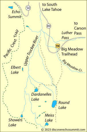
Dardanelle Lake in Meiss Country
Trailhead: Big Meadow Trailhead
Distance: 3.5 miles one way
Elevation changes: +900 feet -500 feet (7,350' - 8,050' - 7,750')
Although Meiss Country is adjacent to Echo Summit, for backpacking the best approach is off Luther Pass (Highway 89), which connects Meyers with Hope Valley on Carson Pass. Five miles from Meyers find the Big Meadow Trailhead. It's part of the Tahoe Rim Trail. Follow the trail south over a ridge. After almost two miles turn right downstream a short distance and then left onto the Dardanelle Lake trail. You'll find plenty of nice campsites around the lake and good fishing.
Other Passes - Other Backpacking Trails
Donner Summit
At the north end of Lake Tahoe Donner Summit (Interstate 80) has miles of trails for backpacking. The Pacific Crest Trail connects with Echo Summit, passing through Granite Chief Wilderness and Desolation Wilderness. Other trails lead off from the Donner Summit area to mountain lakes and spectacular summits. For the best backpacking routes, see Around Donner Summit.
Carson Pass
Just to the south Carson Pass (Highway 88) offers more great backpacking trails. Follow the Pacific Crest Trail south to Carson Pass or take off from Carson Pass trailheads into the Mokelumne Wilderness. For the best backpacking routes, see Up and Over Carson Pass.
Ebbetts Pass
Ebbetts Pass, just south of Carson Pass, has a number of enjoyable backpacking routes. From trailheads along Highway 4 you can strike out into the Carson-Iceberg Wilderness. To learn more, visit our sister website Ebbetts Pass Adventures.
Sonora Pass
Sonora Pass (Highway 108), located farther to the south and just north of Yosemite, is famous for its backpacking in the Emigrant Wilderness
and the Hoover Wilderness. For backpacking ideas on Sonora Pass, take a look at
our sister website, Sonora Pass Vacations.